By Paul Clammer
On my first trip to Haiti, I was, like many people, shamefully ignorant of its history. I had heard of Toussaint Louverture but little of what he did, though I knew enough to realize that packing a copy of CLR James’ The Black Jacobins might be a good idea. It transformed my experience of the country. On repeated visits – most recently working on the new edition of my travel guidebook to Haiti – I’ve always been struck by how the Haitian Revolution continues to inform the discourse of the present, and how the traces of the revolutionary past are still so clearly embedded in the landscape. This photo journal provides an introduction to some of the revolution’s key moments and locations that are accessible to visitors today.

1. Cap Français – Place d’Armes
On the eve of the Haitian Revolution, Cap Français (or Le Cap, modern-day Cap-Haïtien) was the largest town in the French colony of Saint-Domingue. It had a population of around 15,000, of whom two-thirds were slaves and a tenth free people of colour. Le Cap was destroyed by fire twice during the revolution and leveled by an earthquake in 1842, but its original colonial street-plan still carries echoes of its history. The Place d’Armes was the site of many key revolutionary moments, not least the proclamation of general emancipation announced here in 1793. This presaged abolition across the French empire. A modest monument opposite the church commemorates the 1758 execution of the slave rebel Mackandal, as well the 1791 executions of Vincent Ogé and Jean-Baptiste Chavannes, who had fought for the rights of free people of color. The great chronicler of Saint-Domingue, Moreau de Saint-Méry, wrote that when the church’s bell rang, the blacks would cry, ‘A good white is dead, but the wicked ones remain.’[1]

2. Habitation Duplaa
In 1791, there were more than 260 sugar plantations in the north of Saint-Domingue and the ruins of many are still scattered in the landscape, such as here at Habitation Duplaa in Quartier Morin. This plantation survived the revolution largely unscathed; after independence, it was owned by the wife of revolutionary leader Henry Christophe, and later by President Boyer, when it was largely abandoned. Today, it is an active Vodou site, with the lwa (Vodou spirit) Lovana in residence.
Despite this appropriation, the reminders of slavery remain. At the remains of nearby Habitation Dutreille, near the tall chimney for the sugar-boiling works, the gateposts still display the original owner’s motto: Le travail est mon bonheur.

3. Boïs Caïman
This spot at Boïs Caïman marks the Haitian Revolution’s founding event. At this wooded spot on August 14, 1791, a gathering of slaves overseen by the Vodou priests, Boukman Dutty and Cécile Fatiman, pledged themselves to coordinate a revolt against their masters. “The god of the white man calls him to commit crimes,” Boukman announced, “Our god asks only good works of us.”[2] A week later, the skies across the north turned red and black from the burning sugar plantations.
The quasi-mythical nature of the ceremony has led to several places claiming to be the “real” Boïs Caïman. This site, on the old Le Normand de Mézy plantation, is the likeliest location. The thickly wooded hills above are dotted with caves – hideouts for slaves before and during the revolution – including one painted red and blue to dedicate it to the lwa Ogue Feray, the martial spirit said to have inspired many revolutionaries.

4. Breda bridge
This colonial-era bridge outside Cap-Haïtien crosses the river at Haut du Cap towards the Breda plantation, the birthplace of Toussaint Louverture. Although born a slave, by the outbreak out the revolution, Toussaint had been free for 15 years, and had owned slaves as a landowner himself. While the initial stages of the revolution were led by ex-slaves Jean-François and Biassou, by August 1793, he was its main leader. On the day that slavery was abolished in the north of the colony, he announced his claim to colonists “I am Toussaint Louverture. My name is perhaps known to you; I have undertaken vengeance. I want Liberty and Equality to reign in Saint-Domingue,” [3]

5. Môle Saint-Nicholas
The slave revolt in Saint-Domingue quickly took on an international dimension. Toussaint took aid from the Spanish across the border, while British prime minister William Pitt sent troops to try to claim the colony from the French. The British army occupied swathes of Saint-Domingue for five years from 1793 onward, including Port-au-Prince, Jérémie in the south, and the strategic port town of Môle Saint-Nicholas, pictured here. In 1798, Toussaint – then allied with revolutionary France – signed a secret treaty with the British, allowing their troops to evacuate and ending the British blockade of the colony.

6. Burning of Le Cap
After Toussaint became governor-for-life in 1801, the French sent a new expedition, led by Napoleon’s brother-in-law General Charles Leclerc, to return Saint-Domingue under French control. When his forces arrived in Le Cap in February 1802, the revolutionary commander there, Henry Christophe, burned the city to the ground rather than allow him to disembark. This act of defiance is remembered in this plaque at the foot of Christophe’s statue on the Champs de Mars in Port-au-Prince, one of a series erected in 1954 to commemorate the 150th anniversary of Haitian independence.

7. Crête-à-Piérrot
One of the key battles of the Haitian Revolution was the siege of Crête-à-Piérrot in March 1802. The French surrounded the forces of Jean-Jacques Dessalines at this fort in the Artibonite Valley for a three-week siege. Its low walls belie its secure hilltop position – desperate assaults and trench fighting resulted in 1500 French dead. It was here that, according to a white prisoner held at the fort, Dessalines first promised his troops that their struggle would lead to full independence. The defenders eventually ran out of food and water, but still managed to fight their way out and rejoin the rebel armies in the mountains. For the French, the final capture of the now-useless fort was the definition of a pyrrhic victory.

8. Vertières
The last great fight of the Haitian Revolution took place at Vertières, just outside Le Cap. Dessalines – now commander of the self-styled Indigenous Army – amassed his forces to take on the remaining French forces, commanded by General Rochambeau (Leclerc having earlier died of yellow fever). The hero of the battle was Capoix-la-Mort, who led repeated assaults on the French, despite having his horse shot from under him. When the smoke cleared, Rochambeau sued for peace and was granted ten days to evacuate all remaining troops from the island. This monument, by the Cuban sculptor Juan José Sicré, was erected to commemorate the 150th anniversary of the battle, which was accompanied by a full-scale recreation of the fight by the Haitian army. November 18, the date of the battle, remains a national holiday in Haiti.

9. Fort Liberté
After the last French had left the island, Dessalines along with Christophe and General Clerveaux travelled to Fort Dauphin (now Fort Liberté), near the border with Santo Domingo. In front of the French cathedral in the town square (pictured), they announced that “the independence of Saint-Domingue is proclaimed.” Their new country was still in want of a name, but this preliminary statement of independence quickly appeared in translation in newspapers in the USA and England.

10. Gonaïves
Dessalines made his definitive statement of independence for the newly christened state of Haiti in the square of Gonaïves on January 1, 1804. His secretary Boisrond Tonnerre joked that to do true justice to their monumental struggle, the declaration of independence would require “the skin of a white to serve as a parchment, his skull as an inkwell, his blood for ink, and a bayonet for a pen.”[4] The modern monument shows Dessalines at the prow of a slave ship; on its sides, bronze reliefs show its human cargo transformed by their struggle to stand proudly, ready to defend the world’s first black republic.

11. Pont Rouge
The discontents of revolution continued to be felt after independence. The once-enslaved wanted to be free to cultivate their own land, but governor-general, Toussaint had forced them back to the plantations to rebuild the shattered economy. Dessalines carried on this policy of militarized agriculture and unsuccessfully tried to woo the British into a trade treaty. He crowned himself emperor in late 1804. Two years later, a conspiracy of leading generals, including Alexandre Pétion (and with the likely approval of Henry Christophe), led the assassination of Dessalines at Pont Rouge on the edge of Port-au-Prince. This monument on the site of his death was unveiled on October 17, 2015, the 209th anniversary of his murder.

12. Citadelle Henry
Newly independent Haiti feared the return of the French army, and to this end Dessalines ordered a series of forts to be built in the mountainous interior. At the first sight of an invasion flotilla, the port cities were to be burned and the forts serve as bases for guerilla war. The grandest of these was built by Christophe on the summit of Pic la Ferrière near Milot, a cutting edge piece of military architecture whose construction continued after Christophe named himself ruler of the north (and eventually king) following Dessalines’ death. The Citadelle Henry is the largest fortress in the Americas and (together with Christophe’s ruined palace of Sans Souci) Haiti’s only UNESCO World Heritage site, as well as a powerful testament to the country’s long struggle for independence.
Author bio:
Paul Clammer is a writer and guidebook author specializing in Haiti. He is currently researching a biography of Henry Christophe. You can reach at him @paulclammer.
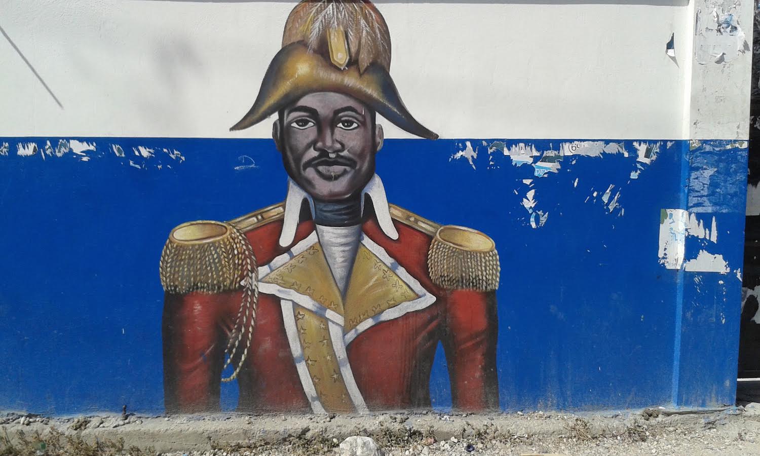
Title image: Mural of Jean-Jacques Dessalines, Lycée Jean-Jacques Dessalines on Avenue Christophe in Port-au-Prince.
[1] Méderic-Louis-Élie Moreau de St. Méry, Description topographique, physique, civile, politique et historique de la partie française de l’isle Saint-Domingue (Paris, 1797) Vol 1, p342.
[2] Carolyn Fick, The Making of Haiti: The Saint-Domingue Revolution from Below (Knoxville, 1990), p93
[3] Laurent Dubois, Avengers of the New World: The Story of the Haitian Revolution (Cambridge, 2004), p176.
[4] David Geggus, Haitian Revolutionary Studies (Bloomington, 2002), p208.
Further Reading:
Jacques de Cauna, ‘Vestiges of the Built Landscape of Pre-revolutionary Saint-Domingue’ in The World of the Haitian Revolution, edited by David Patrick Geggus & Norman Fiering. Bloomington: Indiana University Press, 2009, 21-48.
Paul Clammer, Haiti: The Bradt Travel Guide. Chalfont St. Peter: Bradt Travel Guides, 2012.
Leave a Reply