By Hannah Williams
Paris is famous for its art world. You don’t need to be an art historian to have heard of Montmartre or Montparnasse and to know about the crucial role that the city and its local neighborhoods played in the cultural histories of the nineteenth and twentieth centuries. But what about eighteenth-century Paris? Where were the city’s artists living just a hundred years earlier? This seemingly straightforward question is much more difficult to answer–and not just for non-specialists. In fact, the answer was so buried that it inspired five years of research and digital development, which has recently culminated in the launch of Artists in Paris: Mapping the 18th-Century Art World, an open-access website funded by The Leverhulme Trust and supported by Queen Mary University of London.
I was first confronted with this question in 2013 while researching a book about eighteenth-century religious art made for parish churches in Paris. I was particularly interested in tracing connections between artists and their own local parish churches, but there was no comprehensive study of art world demographics that I could draw upon to find the answer. After undertaking the archival research to find sources recording artists’ addresses (using the unpublished registers of the Académie Royale de Peinture et Sculpture along with the Almanachs Royaux, and the Almanachs Nationaux), I quickly realized that the potential for this geospatial data went far beyond my initial objectives.[1] I began conducting preliminary experiments using Google Maps, plotting all the addresses for randomly selected years, which provided some answers to my initial question. The process also revealed the exciting possibilities that this material held for a broader digital mapping project. It seemed to me that a digital map of the art world could provide new ways of exploring artistic communities in this period, offering a more intimate understanding of how this earlier generation of artists was inhabiting the city.
Overall, the project had three objectives, carried out in three distinct stages: to find primary sources recording artists’ addresses across the century and to extract that data into a machine-readable form; to geo-locate each address and plot them all on geo-referenced historical maps of Paris; and to create a website that would make this data available online through an interactive platform. While the project involved a vast investment of time and creative effort – both by myself and the website’s developer, Chris Sparks (Queen Mary University of London) – the actual tools and software used to conduct the work and build the site were nearly all open-access and freely available (apart from Filemaker Pro, the software I used to build the relational database). For instance, to geo-reference the historical maps of Paris, I used MapWarper, an open source tool for geo-rectification and geo-referencing. To give each address a set of machine-readable coordinates, I used GeoJSON in order to find the longitude and latitude of each manually plotted address. Likewise, in the building of the site, Chris used OpenLayers, an open-source JavaScript library for interactive mapping, along with Bootstrap to create the site’s responsive front-end design. Many of the methods that I used in the preparatory cartographic work were adapted from an invaluable digital mapping tutorial for historians – “From Paper Maps to the Web: A DIY Digital Maps Primer” – designed by Mauricio Giraldo Arteaga for New York Public Library Labs.


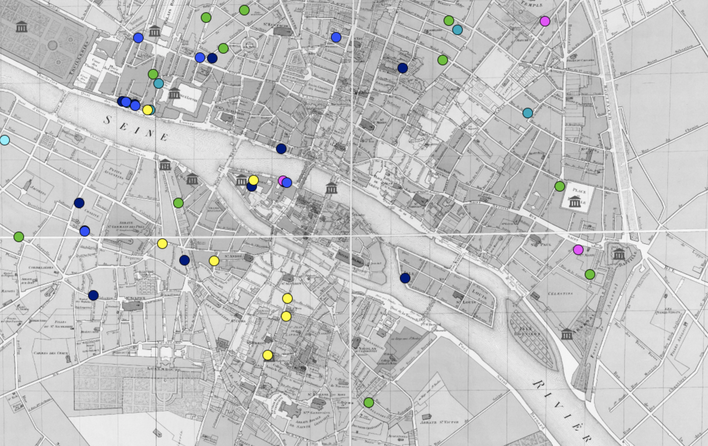
The resulting website – www.artistsinparis.org – invites users to explore the art world of eighteenth-century Paris through two different search modes: year and artist. In a year mode search (e.g. for 1789 in Fig. 1), the map displays all the addresses of artists living in Paris that year, providing a demographic snapshot of the art world at that moment. There is also a date slider allowing easy comparisons year by year to trace the unfolding shifts in Paris’s cultural geography across the period covered (1675 to 1793). In an artist mode search (e.g. for Hubert Robert in Fig. 2), the map displays the addresses of the selected artist, showing all the places he or she lived during his or her career. This allows users to trace more personal narratives about the social and economic lives of particular individuals. Along with the local artistic histories of Paris, the site also grants access to larger trans-regional and transnational histories by including artists who were living elsewhere in France or abroad (e.g. in Fig. 3). Another notable feature is found under “Your Data,” where users can upload their own data to display new markers on the map. This vastly expands the potential field of demographic and geographic analysis and is especially exciting because it changes the user’s interaction with the site, transforming it from a space for information retrieval, to a platform for further experimentation.
This project began as an effort to answer a very straightforward question: where did the artists of eighteenth-century Paris live? This is a question we can now answer in fascinating detail, whether in terms of larger demographic trends (e.g. the gradual formation of a dense artistic neighborhood in and around the Louvre), or more microhistorical investigations of particular artists. What has been even more exciting, however, is the realization that the site’s potential doesn’t just lie in its ability to answer questions, but in its ability to pose new ones, whether about the everyday lives of individuals, or the much larger narratives of the art world or the history of the city. The interactive maps of Artists in Paris play at the intersection of art history and urban history and invite visitors into deeper explorations of artists, cities, and urban experience.
Hannah Williams is Leverhulme Early Career Fellow at Queen Mary University of London. An art historian of early modern France, her research focuses on artistic communities, material culture, religious art, and spaces of the art world. She is the author of Académie Royale: A History in Portraits (Routledge, 2015) and the website Artists in Paris: Mapping the 18th-Century Art World (with Chris Sparks). She has published articles in Urban History, French History, Art History, and Oxford Art Journal, and is currently writing her second book, Art & Religion: Making the Parish Churches of 18th-Century Paris. She is a founding co-editor of Journal18.
Further reading:
Hannah Williams, “Artists’ Studios in Paris: Digitally Mapping the 18th-Century Art World”, Journal18, #5 Coordinates (Spring 2018)
Hannah Williams, “Artists and the City: Mapping the Art Worlds of 18th-Century Paris”, Urban History (online version 2018; print version forthcoming)
Endnotes:
[1] For more detail on the primary sources used and the historical scope of the project, see the FAQs page at http://www.artistsinparis.org.
Leave a Reply